PAS 128 is the UK specification for underground utility detection, verification and location. It is published by BSI, and the current edition is PAS 128:2022. Clients and designers use it to order a utility survey and know exactly what they will get back.
This guide covers the four survey types, the quality levels on a PAS 128 drawing and the survey methods M1 to M4P. It also covers how to brief a surveyor and how the survey is used once digging starts. For the wider safe system of work, see our guide to avoiding utility strikes.
Key points
- PAS 128:2022 replaced the 2014 edition, which BSI has withdrawn.
- It sets four survey types: D (desktop records), C (site reconnaissance), B (detection) and A (verification).
- A Type D records search must come before every other survey type.
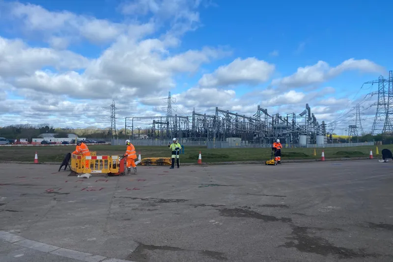
- A Type B survey uses at least two detection methods, usually an electromagnetic locator and ground penetrating radar (GPR).
- Each service on the drawing gets a quality level, from QL-D (records only) to QL-A (seen and measured to within 50 mm).
- The Survey Association says a well designed survey should detect around 80% to 95% of utilities. None can promise 100%.
In this guide
- What is PAS 128?
- Is a PAS 128 survey a legal requirement?
- What are the four PAS 128 survey types?
- What do the PAS 128 quality levels mean?
- What are survey methods M1 to M4P?
- What changed in PAS 128:2022?
- What can a PAS 128 survey not find?
- How do you brief and buy a PAS 128 survey?
- How is a PAS 128 survey used once digging starts?
- Where Ground Utilities fits
- Frequently asked questions
- Planning a utility route?
- Sources
What is PAS 128?
PAS 128 is a Publicly Available Specification from BSI, titled "PAS 128 Underground utility detection, verification and location. Specification". BSI says it "specifies requirements for the detection, verification and location of existing and new underground utilities".
The first edition came out in 2014. BSI published PAS 128:2022 on 30 April 2022 as a full revision, and lists it as current.
The Survey Association (TSA) publishes a client guide to the 2022 edition. It says PAS 128 aims to bring clarity and consistency to how surveys are done. In TSA's words, it:
- classifies how far each result can be trusted;
- standardises the deliverables;
- makes the surveyor accountable.
What PAS 128 does not cover
TSA's guide says the specification does not cover:
- emergency utility works, as defined by the New Roads and Street Works Act 1991;
- overhead lines and other infrastructure above ground;
- basements, tunnels, plant rooms and other features that are not utilities.
Is a PAS 128 survey a legal requirement?
No. PAS 128 is a specification that no law requires by name, and it becomes binding when a client writes it into a contract. The legal duty sits in the Construction (Design and Management) Regulations 2015 (CDM 2015), and HSE's guidance HSG47 explains how to meet it.
| Document | What it is | What it says about surveys |
|---|---|---|
| CDM 2015, regulation 25(4) | Law | Work that could create a risk from an underground service must not go ahead until suitable steps have been taken to prevent it. The test is what is reasonably practicable |
| HSG47 | HSE guidance | Describes levels of survey, from a desktop study to physical identification by trial holes. The level depends on the site, and the designer should decide it at the planning stage with the contractor and surveyor |
| PAS 128:2022 | BSI specification | Binding only when written into a contract. A common way to record the survey level decided under HSG47 |
TSA notes that non-intrusive surveys fall outside the CDM 2015 definition of construction work. A survey ordered as part of a larger project still feeds the information that CDM duty holders need.
What are the four PAS 128 survey types?
The four types are D (desktop records search), C (site reconnaissance), B (detection) and A (verification). They build on each other, and each step costs more and gives more confidence.
| Survey type | What it involves | What you get | Before it you need |
|---|---|---|---|
| Type D, desktop utility records search | Records gathered from every statutory undertaker with assets in the area, and from private owners such as estates or hospitals where relevant | Where the owners believe their services are. No positional accuracy, and possibly out of date | Nothing. Type D is the first step for every survey |
| Type C, site reconnaissance | Type D records checked on site against covers, poles, cabinets, valves and trench scars | Records tied to visible features. No detection, and no depths unless the records show them | Type D |
| Type B, detection | At least two geophysical methods, usually electromagnetic location (EML) and GPR, recorded by satellite positioning or total station | Detected positions, each with a quality level | Type D |
| Type A, verification | Services seen in chambers or exposed in trial holes, with cross-section drawings | Verified position and depth | Type D. Type B is recommended |
How long does a Type D search take?
Allow at least twenty working days. TSA's guide explains the timing:
- National Joint Utilities Group members must answer requests within ten working days, and most do;
- some owners take longer, and some are not members;
- it is good practice to allow that long for a full desktop search.
The 2022 edition dropped the old 90-day validity period for a records search. TSA says all desktop information should now be treated as historical and possibly out of date. The surveyor must get the most recent plans available.
Type A in practice
TSA's guide makes three points about verification:
- hand-dug trial holes and vacuum excavation are the safest ways to confirm a utility's depth and position, wherever no manhole gives access;
- the client should say where trial holes go, based on where services conflict with the design;
- reinstatement can be a large part of the cost, especially in a carriageway.
For how trial holes are dug and recorded, see our guide to trial holes, trial pits and slit trenches.
What do the PAS 128 quality levels mean?
Every length of service on a PAS 128 drawing carries a quality level (QL). The surveyor assigns it after the survey, based on how well each service was detected. The figures below are from Table 1 of PAS 128:2022, as reproduced in TSA's client guide.
| Quality level | Survey type | Horizontal accuracy | Depth accuracy | What it means |
|---|---|---|---|---|
| QL-D | D | Undefined | Undefined | Taken from the owner's record only |
| QL-C | C | Undefined | Undefined | Record checked against visible features on site |
| QL-B4 | B | Undefined | Undefined | Suspected but not detected. Shown as an assumed route |
| QL-B3 | B | Within 500 mm | No reliable depth | Horizontal position only, from one detection method |
| QL-B2 | B | Within 250 mm | Within 40% of detected depth | Position and depth detected with confidence |
| QL-B1 | B | Within 150 mm | Within 15% of detected depth | Position and depth detected with high confidence |
| QL-A | A | Within 50 mm | Within 50 mm | Seen and measured in a chamber or excavation |
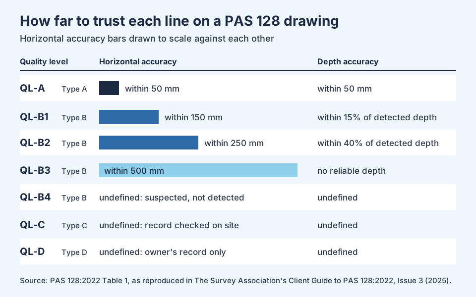
Two rules in the table matter on site:
- A "P" suffix, such as QL-B1P, means the GPR data was post-processed in the office. TSA says this generally means higher confidence.
- A locate by EML receiver alone, not confirmed by GPR, is classed as QL-B3. Readings should come from the signal generator and receiver used together.
TSA also warns that there is no such thing as a "QL-B1 survey". You can order a Type B survey, but the ground and site decide which quality level each service reaches.
What are survey methods M1 to M4P?
A Type B survey is carried out to a set method. The methods use grids of survey lines, run in two directions at right angles. Denser grids find more but cost more.
| Method | Survey grid | Typical use (from PAS 128:2022 Table 2) |
|---|---|---|
| M1 or M1P | 5 m grid, or a boundary survey | Undeveloped areas with few services |
| M2 or M2P | 2 m grid | Suburban areas, or where services cross the survey boundary |
| M3P | 1 m grid | Busy urban areas, or clearance before boreholes, drilling, fencing or tree planting |
| M4P | 0.5 m grid | Congested city areas |
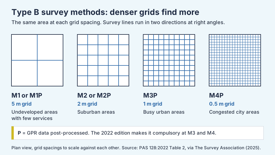
The 2022 edition makes post-processing of GPR data compulsory at M3 and M4, so only M3P and M4P remain. TSA says data from multichannel GPR arrays should always be post-processed.
Post-processing has a knock-on effect. Results may not be marked on the ground until the surveyor returns, so ask for a return visit at tender stage if you need mark-out.
What changed in PAS 128:2022?
BSI lists five major changes from the 2014 edition:
- Guidance on the training and qualifications of practitioners.
- Updates to how post-processing applies in detection surveys.
- A new specification for detecting and avoiding buried utilities, to support on-site permits to break ground.
- New guidance on the accuracy of detection methods.
- New guidance on the technical factors that set the effort a detection survey needs.
TSA adds that GPR survey lines must now be georeferenced and the data kept for a set period, even when it is not post-processed. That gives both client and surveyor an audit trail if something is disputed later.
What can a PAS 128 survey not find?
TSA says a well designed and executed survey should detect around 80% to 95% of utilities. It may not be possible to reach 100%. The common gaps are:
- Very deep services, such as deep sewers, which can be beyond the range of both EML and GPR.
- Service connections to properties. Most surveys map mains only. Small plastic gas and water pipes are hard to detect, so ask at tender stage if you need them.
- Small fibre cables laid straight in the ground. TSA says these are unlikely to be detectable.
- Non-metallic services in poor GPR ground. Saturated or dense soils reduce GPR penetration, and GPR cannot see through metal layers.
- Services under reinforced concrete, which interferes with both methods.
How do you brief and buy a PAS 128 survey?
PAS 128 needs the client and surveyor to work together. TSA says the specification requires a pre-survey meeting, in person or online, so the chosen method meets the client's needs.
Use this checklist when you write the brief:
- ☐ Survey type per area: for example Type D everywhere, Type B where you will build, Type A at conflicts
- ☐ The Type B method (M1 to M4P) for each area, or a request for the surveyor to propose one
- ☐ Whether service connections to properties are in scope
- ☐ Whether GPR post-processing is needed below M3
- ☐ Whether you need the results marked out on the ground, and so a return visit
- ☐ The deliverables: report, CAD drawings, BIM model or GIS data, and the layer conventions
- ☐ Trial hole positions for any Type A work, and who reinstates them
- ☐ Who signs off quality, cost and day-to-day decisions
- ☐ Programme dates, allowing at least twenty working days for the records search
- ☐ Insurance cover. TSA gives typical values of £5 million professional indemnity, £10 million employers' liability and £10 million public and product liability
- ☐ Evidence of competence, such as PUMA accreditation
What is PUMA?
PUMA stands for PAS128 Utility Mapping Accreditation, a TSA scheme for utility survey companies that LRQA runs. TSA says accredited companies show:
- a quality management system;
- trained staff;
- professional indemnity insurance;
- compliance with PAS 128.
TSA describes regular accreditation assessments, with annual supervisory visits in between. It also warns that quotes using different methods may not be directly comparable, so the cheapest quote may not buy the same survey.
How is a PAS 128 survey used once digging starts?
A survey is a starting point for the digging team. HSG47 says survey results should be recorded on working drawings, shared with the people on site and, where possible, marked out on the ground.
The digging team then works through its own checks:
- Brief the gang on the survey drawing and its quality levels. A QL-B3 line has no depth, and a QL-D line has no position.
- Sweep and mark the work area with a CAT and Genny before breaking ground. Services can be altered or added after a survey.
- Dig trial holes by hand or by vacuum excavation to prove services where the work comes close. See why trial holes are dug by hand.
- Record anything found that is not on the drawing, and tell the client and the asset owner.
HSG47 says to use trial holes to positively identify a service and its depth. A PAS 128 Type A result does that at chosen points. Everywhere else, the digging team still proves services as it goes.
Where Ground Utilities fits
Ground Utilities is a utility and civil engineering contractor based in Cottenham, Cambridgeshire. We build multi-utility routes for power, fibre, water and drainage, and HV and LV cable routes from 240V to 132kV.
Specialist utility surveyors carry out PAS 128 surveys, and the client and its designer decide the survey level. The digging team then works from the survey drawing, as set out in the section above. Our project and accreditations pages record that:
- on the Indian Queens 33kV private wire in Cornwall, our scope includes trial holes and HSG47 hand digging at 22 areas of concern;
- we are members of the Utility Strike Avoidance Group;
- all our operatives are CSCS/EUSR registered as a minimum.
What we do not do: we do no gas work and no design. We do not joint or terminate cables, make final live connections to the network, or make connection applications to the network companies.
Frequently asked questions
What is a PAS 128 survey?
A PAS 128 survey is a utility survey carried out to BSI's specification PAS 128:2022. It finds and maps buried services to one of four survey types, from a desktop records search (Type D) to verification by excavation (Type A). Each service on the drawing gets a quality level.
Is PAS 128 mandatory?
No. PAS 128 is a specification, and it applies when a client writes it into a contract. The legal duty to prevent danger from underground services is in regulation 25(4) of CDM 2015, and HSE's HSG47 explains how to meet it.
What is the difference between a PAS 128 Type A and Type B survey?
A Type B survey detects services from the surface, using at least two methods such as an electromagnetic locator and GPR. A Type A survey verifies them by seeing them in chambers or exposing them in trial holes. Type A gives position and depth to within 50 mm.
What does QL-B1 mean?
QL-B1 is the highest quality level for a service detected from the surface. PAS 128:2022 sets it at within 150 mm horizontally and within 15% of the detected depth. A "P" suffix means the GPR data was post-processed.
Does a GPR survey find every buried service?
No. The Survey Association says a well designed survey should detect around 80% to 95% of utilities. Very deep services, small plastic pipes and fibre laid straight in the ground can be missed, and wet or dense soils reduce GPR range.
How much does a PAS 128 survey cost?
It depends on the survey type, the method, the size of the site and whether data is post-processed. The Survey Association says higher survey types and denser methods cost significantly more. Get quotes on the same type and method so you can compare them.
Planning a utility route?
Tell us the route, the utilities and the programme, and we will come back to you. Send an enquiry or call 01223 423918.
Sources
- PAS 128:2022 Underground utility detection, verification and location. Specification (BSI, 2022)
- Client Guide to BS: EN PAS 128:2022, Issue 3 (The Survey Association, May 2025)
- Avoiding danger from underground services (HSG47), third edition (Health and Safety Executive, 2014)
- The Construction (Design and Management) Regulations 2015, regulation 25 (legislation.gov.uk)